Phillips 66 Refinery, Soil Program and Surface Water/Groundwater Remediation

About these cleanup sites
Phillips 66 Refinery:
Location: Duncan, Stephens County, Oklahoma
Latitude/Longitude: 34°25’23.7″N, 97°57’19.8″W
Section, Township and Range: Section 32, Township 1S, Range 7W; N/2 Section 5, Township 2S, Range 7W; SW4 NW4 NW4 Section 4, Township 2S, Range 7W
Site Type: Refinery
Area: 440 acres
Voluntary Cleanup Program: Order No. 02-393 (2003)
Current Status: Active
Click to View Interactive Site Map
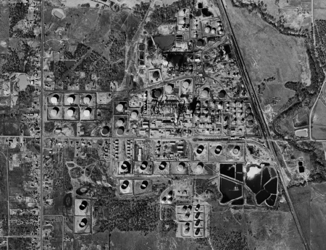
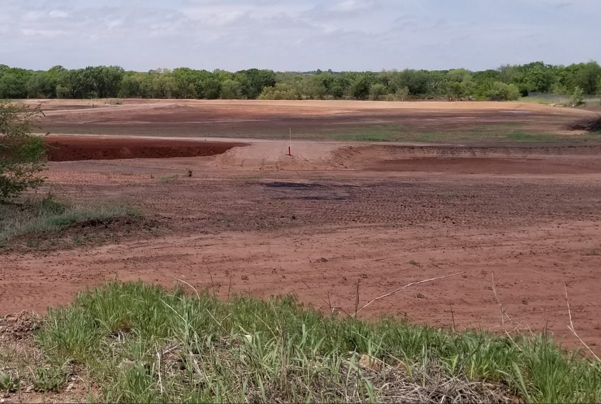
Map – Before and After Cleanup
Cleanup Oversight Agencies: DEQ
Responsible Party: Phillips 66 Company
Office: DEQ, Land Protection Division, (405) 702-5100
DEQ Duncan Refinery Project Manager: Todd Downham, (405) 702-5136
DEQ Press Contact: Erin Hatfield, (405) 702-7119
Site History and Background:
The former Phillips 66 Refinery is a site with a complex operational history. The property changed ownership several times during its operation from 1921 to 1983, originally housing shell still batteries, boiler houses, and storage tanks. Oklahoma oil fields supplied crude oil used to produce gasoline, diesel, and oil by-products that were shipped throughout the country. In 1943, the facility produced aviation fuel to assist with World War II efforts. At its peak, the refinery was able to process 51,000 barrels of oil per day. Several areas within the site were dedicated to residential housing for plant workers. Tosco Corporation concluded the refining operations in 1983. Since its closure, the property has changed hands several times while remaining out of operation. It is currently owned by Stephens County, and its environmental liability is retained by Phillips 66 who acquired Tosco in 2001.
The refinery contained a catalytic cracking unit used to remove sulfur and phenolic compounds from processed gasoline. The collected sulfur was converted into pellets at the onsite sulfur plant. Salts, chlorides, and caustic wastes created during refining processes were disposed of into storage tanks and ponds. Coke was produced using residual oils. The coking processes included a coker unit, a coke yard, a rail spur, and a receiving pond. Alky-lime ponds (ALPs) were used to dispose of sludge wastes created during lime neutralization of hydrofluoric acid. Some caustic waste was transported to disposal ponds across Claridy Creek by pipeline. The caustic wastes reacted with the atmosphere and groundwater causing secondary pollutants. Refinery wastes were disposed of at a 14-acre area from 1981-1986. The wastes contained polycyclic aromatic hydrocarbons (PAHs) contaminating soil, sediments, and surface water. Volatile organic compounds (VOCs), PAHs, and light non-aqueous phase liquids (LNAPLs) contaminated groundwater. Benzene, a carcinogen, was detected in one monitoring well. Phenol seeps caused by caustic waste sites from the 1950s-1960s contaminated soils and migrated into Claridy Creek. The contaminants flowed downstream into a southern tributary. Arsenic and lead from refining processes contaminated surrounding soil, sediments, surface water, and groundwater.
Multiple environmental investigations have taken place since 1979 to determine the potential human and environmental health risks. In 2001, the DEQ and U.S. Environmental Protection Agency (EPA) analyzed the surface water, sediment, soils, and groundwater to quantify hazards at the refinery, adjacent properties, and along Claridy Creek. In 2003, Phillips 66, Stephens County, and the Oklahoma Department of Environmental Quality (DEQ) established a cleanup agreement. The site remediation is completely funded by Phillips 66 and is in the DEQ Voluntary Cleanup Program (VCP). The remediation plans were put in place to remove hazardous materials, decommission surface structures, and restore surface and subsurface materials to conditions that are within regulatory standards allowing for future industrial development.
Cleanup History:
In the 1960s, above ground caustic waste storage tanks were removed by Sunray Corporation. Several environmental investigations were performed between the late 1970s and 2003 to determine the degree of contamination within and around the refinery site.

Cleanup Status:
Characterization studies evaluated site specific risks based on environmental standards. The project was divided into Phase 1 and Phase 2. Phase 1 involved removing hazardous materials from the site and demolishing surface structures. Demolished facilities included boilers, buildings, workshops, laboratories, onsite dumps, coker units, and underground pipelines. Multiple storage tanks and processing/loading areas were disposed of. Asphalt pits and areas for lead storage were excavated and removed. Caustic waste material was excavated and moved to an offsite landfill. Air quality during dirt removal was within EPA standards. Phase 1 was completed in 2006.
The main goal of Phase 2 is to address all hazardous surface and subsurface conditions.
- Soil gas surveys identified areas of petroleum hydrocarbon and LNAPL sources in the subsurface.
- Two short-term trenches were installed to recover LNAPLs and prevent migration into Claridy Creek with minor results. Monitor wells are inspected each quarter to access LNAPL migration.
- Stained and tar-like surficial soils (similar to the color and constancy of peanut butter) were excavated to depths 1’-3’ to remove all contamination. Sediment samples were analyzed and monitor wells were installed to determine the limits of contamination.
- Elevated organic and inorganic substances were found at twenty two onsite locations resulting from coke processing, transport, and disposal. Approximately 171,600 tons of coke material was removed. Soils containing organic and inorganic contaminants were taken to offsite landfills and replaced with new fill. Approximately 5,000 tons of soil (containing only elevated organic compounds) qualified for bioremediation. A fixing solution was applied to soils and paired with several weeks of aeration to breakdown PAHs.
- ALP soils were blended with Portland cement to decrease leaching and create a more stable material during transportation to offsite landfills. Mixing activities generated the release of more than 1.5 million gallons of hydrocarbons and waste water. These materials were pumped and taken to an offsite treatment facility. Odors from ALPs were suppressed with odor-control foam, airborne deodorizing agents, and soil covers. On- and offsite air quality monitoring ensured there was no exceedance of regulatory standards for workers or neighboring residential areas. Excavated areas were covered with clean soils and revegetated.
- Approximately 11,250 tons of soil containing elevated lead and/or arsenic was excavated (mainly from a northern disposal area and along the train rails). The area was backfilled with clean soil and contaminated materials were disposed of at an offsite landfill. Lead and arsenic removal operations were complete in 2017.
- Migration of odorous phenol seeps into the west banks of Claridy Creek were a main concern for remediation as it is the primary target of groundwater discharge. Contaminated bank soils and sediments were excavated and disposed of at an offsite landfill. In situ chemical oxidation (ISCO) remediation was used to assist in the phenol area cleanup. ISCO involves injecting oxidizing chemicals (like hydrogen peroxide) into monitor wells. The oxidants break down fuels and solvents into less toxic and less odorous chemicals. Phenol soil removal and ISCO was completed in 2019.
- Biologic (vegetation, mulches) and manufactured (silt fencing, erosion control mats) controls have been installed to prevent pollution migration and storm water erosion.
The DEQ continues to work with Phillips 66 and monitor the environmental processes at the former refinery. Phase 2 is currently in progress. Additionally, further groundwater monitoring and remediation may be required after completion of the reclamation efforts.
Land Use Restrictions:
This site is being remediated for future commercial and industrial purposes. The location should not be used for any recreational activities. Storm water ponds are currently maintained on the property for use by Stephens County. Water wells are restricted from being installed. Plans are being developed to supply the property with municipal water.
Regulatory Profile:
- Sources of Contamination: Historical waste material from petroleum refining plant
- Contaminants of Concern: Hydrocarbons (LNAPLs, PAHs), coke, arsenic, lead
- Media Affected: Soil, sediment, surface water, and groundwater
- Surface Water Impacted: Claridy Creek
Read Supporting Documents

